|
LOCATION:
In
Bishop Creek canyon at the roadend in Aspendell in the Eastern
Sierra, just west of Bishop, Ca.
|
| DESCRIPTION
|
reported
by Johnathan Behr
|
|
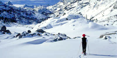
Have you ever dreamed
of seeing the jagged peaks of the "High Sierra" caked in a heavy
snowpack, far away from the ski lift crowds? Whether
you've had that dream or not, consider this snowshoe or cross-country
ski route up Hwy-168, (which is gated at Aspendell for the winter),
into the one of the Eastern Sierra's most awesome glacial canyons.
The road closure at 8,500 feet gives you easy access to the snowy
high country and the magnificent peaks of the Evolution Crest,
all of which exceed 13,000 feet. To view these lofty giants after
a heavy snowfall is an experience of unbelievable beauty. They
will simply make your jaw drop! Clear day views on this excursion
are breathtaking! The huge frozen expanse of Lake Sabrina backdropped
by Mount Haeckel (elev.13, 418 ft.), Mount Fiske (elev.13, 503
ft.) and Mount Huxley (elev. 13,086 ft.) is a Sierra masterpiece.
Add to that, the panoramic views of the White Mountains and the
volcanic tablelands of the Chalfant Valley to the northeast, and
you have day's worth of vistas, you'll remember for a lifetime!
The scenery here is on a grand scale. Enjoy, and remember to dress
in warm, waterproof layers for winter conditions. Gaiters and
snowshoes are an essential! Backpackers will find outstanding
winter camping opportunities on this trip! |
THE
ROUTE
Simply
park your car at the locked gate on HWY-168 in Aspendell and head
out on the snow covered road towards your first destination, Lake
Sabrina.
In about 2 miles and 600 feet of gradual elevation gain, you will
reach this frozen gem, situated at 9,132 feet. From here, retrace
your steps back down HWY-168 for about a half-mile, till you see
a road to your left that is signed for North Lake. Turn left and
head up the narrower North Lake road for about 1 mile to frozen
North Lake (elev. 9,360 ft.) From here, you can continue up the
road to the trailhead for Piute Pass and the true backcountry
of the John Muir Wilderness, or you can call it day and head back
the way you came. |
|